The economic development of the western region of the United States is carried by a river that is known as the Colorado River.
Originating in the Rocky Mountain National Park in north-central Colorado, this river flows northeast-southwest for a total length of 2,330 kilometers, with its source in the mountains above 4,000 meters. The Colorado River is the largest river in the world that is mostly located in the United States.
The word "Colorado" is Spanish for "red," and the river basin is known for its brown Gobi and red landscapes. Early Spanish explorers named the area Colorado due to its distinctive terrain.
Large-scale development of the Colorado River's water resources began in 1936, supporting the economic development of several arid cities in the southwestern United States. However, due to excessive water withdrawals, the river has had little water flowing into the sea since 1998.
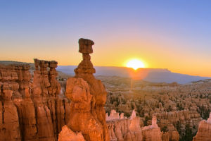
The Colorado River cuts through the world-famous Colorado Grand Canyon after entering Arizona, with the mainstream creating the steep and straight "Marble Canyon."
To make better use of water resources for economic development, the United States has built nearly 10 dams on the Colorado River since the 1930s, including the famous Hoover Dam and Glen Valley Dam. These dams have created famous scenic spots such as Lake Powell and played a significant role in promoting local economic development and regulating the climate.
However, their impact on downstream water use and the ecology of the watershed area has been criticized. With the changing climate environment, the Colorado River is now facing the test of water shortage and cut-off, and its role is being sharply reduced.
The construction of a reservoir dam has completely changed the water distribution in the basin and has had a significant impact on the local ecology. Fish migration routes have been cut off, the huge drop in the river's rise and fall during the rainy season has been curbed, and the unique environmental balance of the canyon has been altered.
Mexico, located at the lowermost part of the river, has suffered a serious impact, with the salt content jumping from an annual average of 800 mg/l to 1500 mg/l at the national border, causing crops to die in Mexican irrigation areas.
In the past, excess water upstream was released underwater, facilitating the dilution of salty water. However, in the last 20 years or so, the Colorado River in Mexico has plummeted due to the interception of upstream reservoirs.
The Colorado River is responsible for the water supply of seven western states as well as two Mexican states, and the Colorado River delta region is an important agricultural area in Mexico, with tens of millions of acres of farmland growing on the river's water.